Page 4: The West. Mare Orientale Page 1: The South East. Page 2: The East. Page 3: The North East. Page 5: The North West. Page 6: The South West.
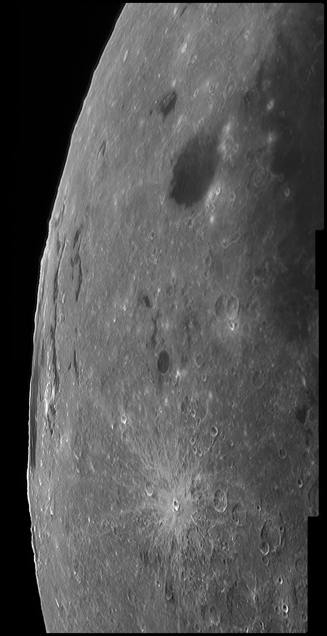
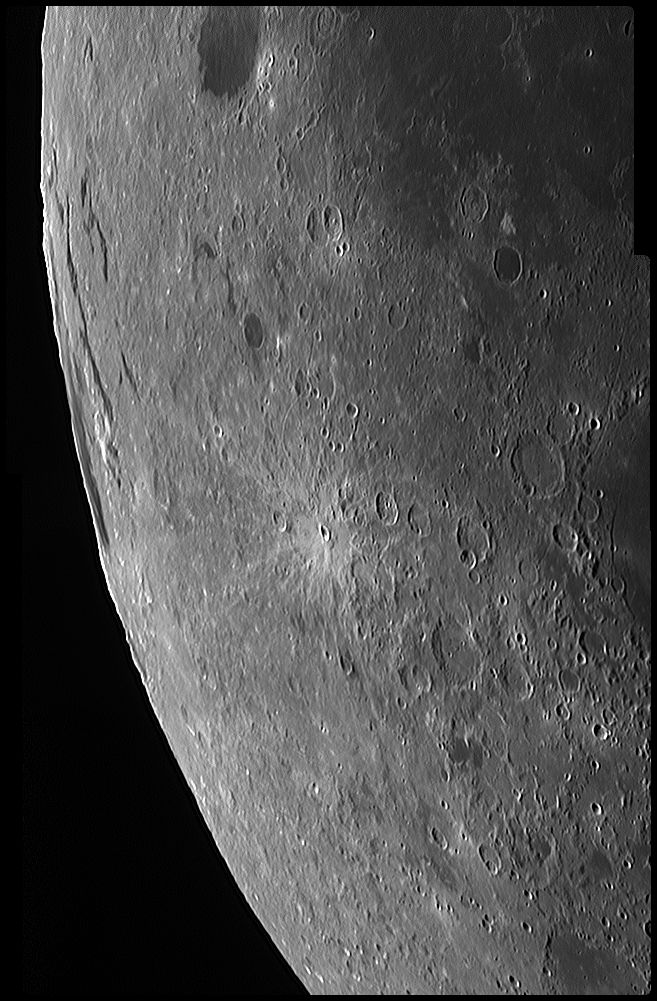
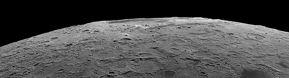
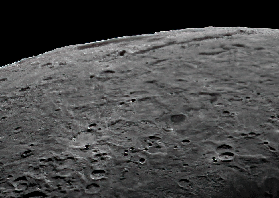
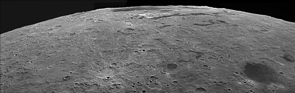
Mare Orientale occupies the most pristine, multi-ring, impact basin on the Moon. Sadly it is located largely on the far side and is only visible from Earth during periods of favourable libration. As a result, the true nature of this basin was only revealed by images from spacecraft (Lunar Orbiter and Clementine). The pictures below were taken during a period of exceptionally good libration for this area. However, they had to be taken in daylight because there is very little darkness at this time of the year where I live and, at this phase, the moon only rises high in the sky after the Sun is up. However the use of an infrared-pass filter cuts out much of the glow from the blue sky and good pictures can be obtained (for other examples see here.) The first two pictures below are both mosaics of two or three separate frames. The pictures are rather flat because the phase of the Moon (days 21.8 and 22.9) meant that the Sun was overhead on this part of the Moon and so there were few shadows. This is always a problem imaging the limb areas, either the Sun is high in the lunar sky or it is behind the camera, either way there are few shadows to bring out the detail. In particular the outer ring of mountains, the Cordillera, really do not show at all. They are steeper on the western side (the inside of the ring) and in the first picture below the Sun was about 13° west of north as seen from that part of the Moon (latitude 80° west). In the second picture, taken a day later, the Sun had only moved to about 25° from north so little more detail was showing. The third picture below was taken 2 days later when the Sun had sunk to 40° above the lunar horizon. I only managed the one frame; on day 25.2 of the lunar cycle, the Moon was only 32° higher in my sky than the Sun, so a fainter Moon was in a brighter sky making imaging even more difficult. (I should have got up earlier!) Many craters have become more visible, but the Cordillera Mountains are still not clearly visible. I have departed from my usual practice of using the formal names on my mouseovers and the common names in my notes for the Rook Mountains. Montes Rook includes both the inner rings of the basin and are distinguished as the Inner Rook and Outer Rook mountains. Lacus Veris is a long slender strip of mare lava falling between the two rings on their eastern side. Similarly, Lacus Autumni falls between the outer Rook Mountains and the Cordillera Mountains. Move your mouse over the picture to see the names of the various features. I have modified the way I post-process my images in Registax. After stacking, I now stretch the histogram to the maximum extent of the data within the image first and apply the wavelets afterwards. I think this produces better pictures than my old way of doing the wavelets first. In the case of histograms, each frame is stretched to fill the same range of intensities, so that when I combine them in iMerge I do not need to use the autobrighten feature which, I find, tends to produce ever darkening (or brightening) images as one stitches up a mosaic of the complete Moon. The image above was taken four days after the previous one (on Lunar Day 25.5), so that now the light is coming towards the camera. The libration is slightly less favourable but the far side of the Inner Rook mountains is still visible on the limb. But the Cordillera mountains are still not clear in the image. On the mouseover I have indicated where the three rings intersect the limb and the Cordilleras run roughly through Schaler and Eischstardt, and Lacus Autumni is inside the ring. Similarly Lacus Veris is inside the Outer Rook mountains. Click on the image to see the full-sized picture and a discussion of the features of the Orientale basin and the problems of photographing it. The image above was taken on Day 24.4 when the libration was very good for this part of the Moon. It was taken at 05:04 UT in conditions on Earth about as bad as they could be. I could only manage a single 2-minute capture before the Moon disappeared behind ever-increasing cloud. Indeed the poor conditions can be seen from the ridiculously long exposure time I had to use. It is largely thanks to John Leach of the Mexborough & Swinton Astronomical Society and his skills in post-processing that I have a presentable image. In this image of the Orientale Basin, I have managed to render the foreground details much bettre than before. In particular, at the bottom of the picture, I have captured part of the Sirsalis Rille which was described by Chuck Wood in his LPOD of 20 January 2012 repeated on 2nd December 2021. Since there is much to talk about in this image I have made it a link to another page where I show a larger version with a mouseover.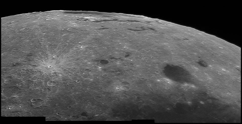
A new picture of Mare Orientale taken on Day 21.4 at much the same phase and libration as for the images above. It was taken in infra-red light and I used the ×2 teleadaptor lens on my LX200 telescope. The picture is a 2-frame mosaic.
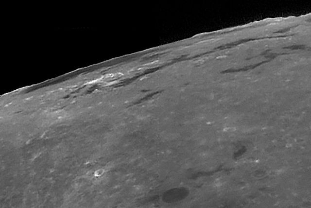
I have rotated this picture 90° clockwise from the original. North may be taken as parallel to the limb and doesn't change much in a small area. For example a line through Darwin C and Rocca A is about 8½° east of due north. West is roughly at right-angles to the limb. I show no scale markers. There is too little detail for me to determine scale at all accurately and, in any case, it changes quite dramatically across the picture.
Date and Time: 9th October 2020 05:27 UT
Lunar Phase: 279.4°
Colongitude: 177.6°
Libration: Latitude -1° 13', Longitude -6° 59'
Camera: DMK 21AF04
Telescope: LX200 with ×2 teleadaptor lens
Capture: ICCapture. 1/218", gain 1023, 1780 frames
Processing: Registax6. 38 alignment points, 400 frames stacked per point. Gaussian wavelets Scheme 10, gamma 0.7
The picture is a mosaic of four pictures merged in iMerge.
Date and Time: 13th October 2020 06:00 UT
Lunar Phase: 229.8°
Colongitude: 126.6°
Libration: Latitude -5° 42', Longitude -5° 51'
Camera: DMK 21AF04
Telescope: LX200 with ×2 teleadaptor lens and IR-pass filter
Capture: ICCapture. 1/367", gain 1023, 1800 frames
Processing: Registax6. 35-40 alignment points, 400 frames stacked per point. Wavelets 1-2=10.
Focus Magic 4.
Date and Time: 31st October 2021 05:04 UT
Lunar Phase: 242.3°
Colongitude: 215.1°
Libration: Latitude -6° 20', Longitude -6° 47'
Camera: DMK 21AF04
Telescope: ETX125 with IR-pass filter
Capture: ICCapture. 1/23", gain 1023, 1876 frames
Processing: Registax5, 891 frames stacked, wavelets 1-2=10
John Leach, DeNoise, Sharpen AI, and Photoshop to increase the resolution to 150 and various other subtle adjustments that have made a huge improvement to my original image.
Finally a pass through Focus Magic, with a radius of 2, sharpened the image just a little.
The image is a mosaic of three frames, taken on Day 23.9.
Date and Time: 29th November 2021 06:41-56 UT
Lunar Phase: 248.9°
Colongitude: 208.7°
Libration: Latitude -5° 29', Longitude -7° 11'
Camera: DMK 21AF04
Telescope: LX200-10 with IR-pass filter
Capture: ICCapture. 1/500", 1/367", 1/183", gain 1023, ~3380 frames each
Processing: Registax5, ~3000 frames stacked with drizzling, wavelets 1-2=10
Mosaic assembled in iMerge and passed through Focus Magic 4 pixels.
Home Return to The Moon