
Due to the size of some of the pictures here, which I do not want to reduce, this page requires scrolling on systems with screen widths less than 1440 pixels.
Orientale is the best example of a multi-ring basin on the Moon. Unfortunately it is situated almost entirely on the far side of the Moon, as defined by the 90°W longitude line which just skirts the eastern edge of Mare Orientale. Consequently it only becomes visible from Earth when the libration is particularly favourable.
Below is a half-sized image from 29th November 2021. Click on the image to see the full-sized picture (and your Back button to get back here). Move your mouse pointer over the image to see various features identified. I have not included scale markers; the scale changes markedly across pictures near the limb and even directions can be misleading. For example, on the limb, North is along the limb everywhere in this picture. The picture has been rotated about 110° clockwise from where it ideally should be. There are several things in this image worthy of comment.
LRO = Lunar Reconnaissance Orbiter, a spacecraft in orbit about the Moon with a high-resolution camera and an altimeter. The LRO data can be accessed from the LRO Quickmap from whence we can see details of the surface in incredible detail, and also access the altimeter for profile determinations. A very useful and valuable tool.
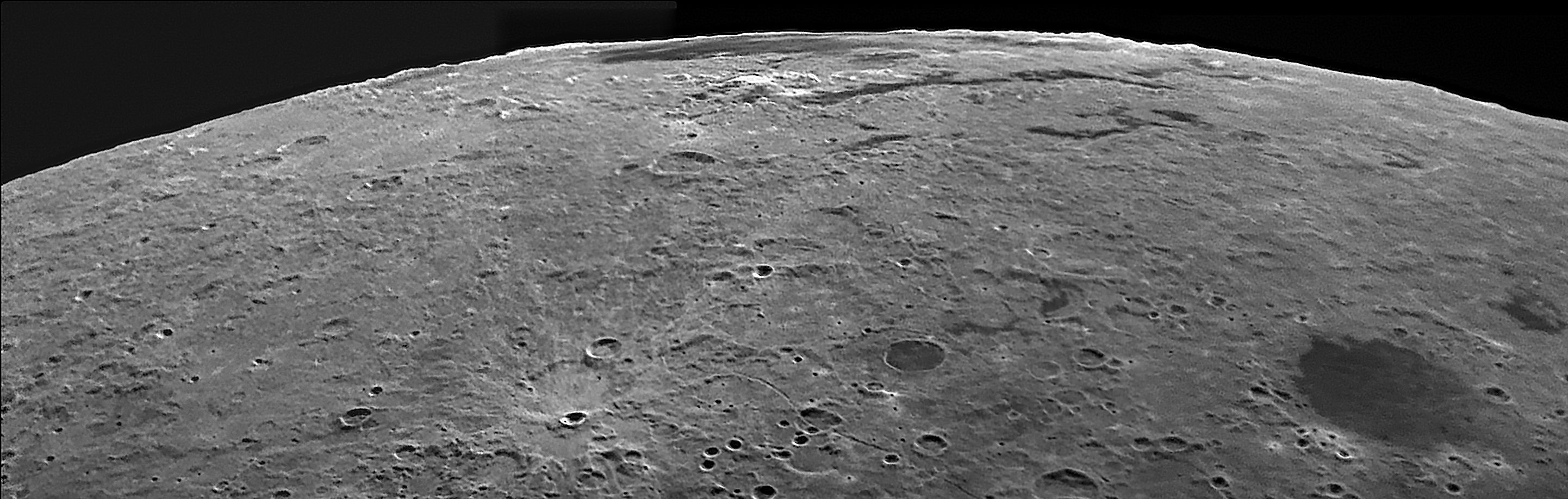
| It is never easy to see the ring structure of the Orientale basin in pictures taken from Earth. Indeed it was not until 1961 when Bill Hartman was working on The Rectified Lunar Atlas, by projecting images onto a white sphere and rephotographing them from above, that the ring structure was discovered. I have yet to obtain a picture that reveals the Cordillera Mountains despite the fact that they were known long before 1961. Lacus Autumni (see mouseover) lies within the Cordillera circle which continues through Eischstadt and Shaler with Wright falling inside the ring. The area between the Cordilleras and the Outer Rook Mountains is visibly flat. Originally only one set of mountains west of the Cordilleras were recognised and named the Rook Mountains, but, when images from overhead (see image from the LRO on the right) indicated that there are in fact two inner rings around Mare Orientale, they were called the Inner and Outer Rook Mountains. In my image, above, it may look as though the mountains that can be seen along the limb might be a continuation of the Outer Rook Mountains, but this cannot possibly be the case and they are undoubtedly the far side of either the Inner Rook Mountains or the scattered mounts that seem to define another, innermost, ring (see mouseover of the image to the right). There is a lone mountain just to the left of the crater on that innermost ring which could well be the feature you can see on the limb just to the right of the gap in the line of mounts. My horizon probably runs from there across the tiny crater you can see just below it (which is named Il'in after a Soviet engineer). The Orientale basin is believed to have formed about 3,800 million years ago and any craters existing in this area at that time would have been covered in ejecta. So any fresh-looking crater here must be younger than that. In particular, at the bottom of the picture, Byrgius A is the centre of a ray system which can just be seen here, and is a bright crater in other pictures of this area. This must be less than 1,000 million years old. This may also explain the flat-looking area between the Cordillera and Inner Rook Mountains. This area must have been smothered in ejecta mixed with rock melted by the impact (called impact melt). Using the LRO Quick map, it is possible to use the altimetry data to map the roughness of a piece of this area. It looks very like the "flat" areas on the floor of larger craters such as Copernicus or Tycho. |
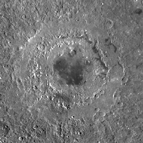 |
| Another interesting crater is Cruger. It is 45 Km in diameter but only 500 metres deep. It is filled almost to the rim with lava so certainly looks like a normal lava-filled crater. But there are other possible explanations. Lava has certainly come to the surface in a number of places here. Just to the north (right) of Cruger is Lacus Aestatis and just north of that we see Rocca A, which at first sight seems to be a crescent-shaped crater with a high southern wall. But the eye is being deceived here. The dark area is not shadow (shadows in other craters show that the Sun is towards the upper right of this picture) but is lava and what we see here is a small lake (a pond, Lacuna Rocca maybe?). In a view from the LRO (right) it looks a normal crater half filled with rubble and with a lake of lava on its floor. The picture also shows Lacus Aestatis and Cruger. On the edge of my picture is Grimaldi. According to Wood in his book The Modern Moon the rim of Grimaldi is the inner ring of a multi-ring impact basin that predates Orientale so that the rest of the Grimaldi Basin has been obliterated by the Orientale ejecta. The remnants of the outer rings do not show in this picture. |
|
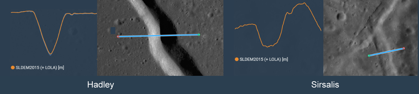
| Finally at the bottom of the picture, you can see the Sirsalis Rille. This is a strange feature discussed by Chuck Wood in his LPOD column of 20 January 2012 repeated on 2nd December 2021. There are two types of Rille on the Moon. There are the Sinuous Rilles which look like meandering rivers; a typical example is the Hadley Rille. These are caused by a flowing fluid, not water of course on the Moon, but volcanic lava. The other sort are graben, which are caused when a block of surface between two faults drops downward. These are generally straight with sloping sides and flat bottoms. A typical example on the Moon is the Ariadaeus Rille just west of Mare Tranquillitatis. The Sirsalis Rille is of this latter type as can be seen on high-resolution images from the LRO. Below are diagrams showing the cross-sectional profile of the Hadley and Sirsalis rilles along with where I measured them. It is immediately obvious that the cross-sections of the two rilles are quite different. (Please note that the scale of the vertical axis in both cases is much larger than the horizontal one giving an exaggerated impression of the depths of these rilles.) Hadley is about 1.5 Km wide and 300 metres deep and has a profile not unlike that of a simple crater, but Sirsalis is about 2.8 Km wide and 200 metres deep. Sirsalis has cut through sloping ground and the bottom of the rille appears to slope in the same direction as the surface. However this is not the strange aspect of the Sirsalis Rille. | |
 |
|
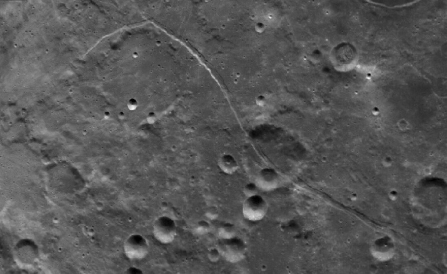 |
Rilles of this type are generally more or less straight, and over most of its length this rille is too. Indeed it can be seen to cut right through the crater De Vico A. But at its southern end it curves around what looks like an ancient crater. You can see this in this picture (left) taken from the LRO (north is to the right to conform to my other pictures), which also shows the rille cutting through De Vico A. The reason why the rille curves around this unnamed crater is nor clear. The crater is evidently older than the Orientale basin since it appears to be full of ejecta. The rille must be younger than the basin (or it too would be full of ejecta) and must also be younger than De Vito A, but it is not clear to me whether or not De Vito A is younger than Orientale. A graben is usually formed when a section of crust is stretched until it breaks. Usually impact events cause compression, but when the compression wave passes, the rocks relax. Central mountains are created by compression waves rebounding and pushing the mountain up. However these waves have been downwards, and it is difficult to see horizontal waves being reflected in the same way, but basin formation is an extremely violent event and who knows how the pressure waves interact with existing features? This unnamed crater is some 800 Km from the centre of the Orientale basin, almost twice the distance of the outer ring. If the pressure wave reached this far with great enough intensity, could it reflect from the then empty crater and cause the rock to crack in this arc? The ejecta would have arrived seconds later but would the crack have opened by then? I am speculating. The impact event took minutes at most, but 3,800 million years have elapsed since then; plenty of time for things to settle down or be modified by subsequent events. |
Home Return to The Moon