Fra Mauro 
Move your mouse over the picture to see the names of the various features.
|
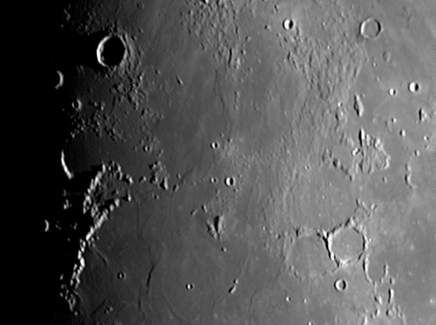
This area is usually designated as the northern part of the Mare Nubium with Oceanus Procellarum further to the west (in the shadow in this picture). However in the 1970s the region was renamed Mare Insularum (The Sea of Islands), but there appears to be scanty evidence that there is an associated basin. (Does a mare have to have a unique associated basin?) After Ranger 7 provided the first close-up pictures of the lunar surface here, the area was called Mare Cognitum (The Known Sea).
The area contains the landing sites of both Apollo 12 and Apollo 14.
The scale markers indicate approximately 100 Km north and east.
The picture was taken with my LX200 on 18th February 2005 at 20:57 UT when the Moon was 10.0 days old.
Date and Time: 18th February 2005 20:57 UT
Camera: ToUcam 740K
Telescope: LX200
Capture: K3CCDTools. High gamma, 1/250", 10% gain, 455 frames
Processing: Registax. 275 frames stacked. Wavelets 1-2 = 10, wavelet 3 = 5
|
|
|
|
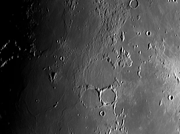
This is essentially the same picture as above. The lunation is very nearly the same, but the libration has moved the Moon about 2° to the west resulting in slightly different lighting. This has brought out some interesting features of this area (or maybe it is just a better picture!)
A massive cleft can be seen starting near an unlabelled crater west of Fra Mauro h and running south through Fra Mauro, through Parry, past Tolanski and off the bottom of the picture. This is Rima Parry I. It is radial to the Imbrium basin and so may be a result of that huge impact 3,800 million years ago. Most of the craters here are older than that and the crack passes through the walls of Parry. The western side of Fra Mauro also looks as though it is filled with rubble. Is this debris thrown out by the Imbrium impact 1300 kilometres away? Rocks picked up at the landing site of Apollo 14 (only 70 Km to the north) were breccias, composite rocks containing sharp pieces that look as though they were produced by the shattering of rock, and glassy material that may be rock melted by the impact.
The scale marks in the bottom left-hand corner indicate approximately 100 Km north and east.
The picture was taken with my LX200 on 10th December 2005 at 20:13 UT when the Moon was 9.8 days old.
|
| Date and Time |
10th December 2005 20:13 UT |
Camera |
ToUcam 740K |
Telescope |
LX200 |
Capture |
K3CCDTools. Low gamma, 1/25", 42% gain, 416 frames |
Processing |
Registax. 96 frames stacked. Wavelet 1 = 10, 2 = 5, gamma 1.3 |
| |
|
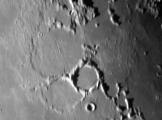
An ancient and battered crater, Fra Mauro is about 4,000 million years old. It is 100 km in diameter and appears to have been flooded by lava from Mare Nubium. Although the wall of Parry is intact, its floor has been flooded to about the same level as Fra Mauro. It is 50 Km in diameter but only 560 metres deep, which is not nearly as deep as a crater of this size should be.
Apollo 14 landed just north of here. Click on the image below to see a maosaic of the area indicating the landing site.
The scale marks in the bottom left-hand corner indicate approximately 50 Km north and east.
The picture was taken with my LX200 on 7th October 2004 at 03:18 UT when the Moon was 22.8 days old.
|
| |
|
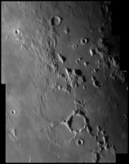
Click on the image to see a mosaic covering a larger area around Fra Mauro. |
| Date and Time |
7th October 2004 03:18 UT |
Camera |
ToUcam 740K |
Telescope |
LX200 with X2 teleadaptor lens |
Capture |
K3CCDTools. High gamma, 1/50", 33% gain, 313 frames |
Processing |
Registax. 162 frames stacked. Wavelet 1-3 = 10 |
Home Back to SW Quadrant