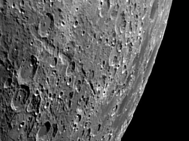
Vallis Rheita 
Move your mouse over the picture to see the names of the various craters.
This picture produced some questions in my mind and led me to an investigation of perspective and alignment. In the hope that this may be interesting and informative to you, I recount this below the first picture. If you are just interested to see a picture of this feature, then you may wish to restrict your reading of this page to the first picture. If you are interested in the alignment of this valley and its implications to its origin, then read on.
The main picture was taken on day 6.6 of the lunar cycle during a period of favourable libration, 7° 17' in longitude and 3° 1' in latitude, so the distortions I describe are actually less than usual. This libration exposes Mare Australe too but I have a more detailed picture of that elsewhere at even more favourable libration.
|
The Rheita Valley is a long depression consisting of a series of overlapping craters. The northern part, from Rheita to Young D is larger and more distinctly a deep cleft. The southern part, from Young D towards Mare Australe and sometimes called the Mallet Valley, looks much more like a string of small craters. Both parts are roughly radial to the Nectaris basin and it is generally accepted that they are both formed by ejecta from that basin.
Taking the valley as one continuous one, there certainly appears to be a bend at or about Young D. However, whenever I construct the scale markers on my pictures, I am conscious of how both directions and scales change as one approaches the limb. Could it be that the valley is straighter than it appears to be and the bend is caused by the perspective of the view we get from Earth?
The scale markers are approximately 100 Km north and west and apply at Young D.
Date and Time: 9th June 2008 20:41 UT
Camera: Atik 1-HS
Telescope: LX200 at prime focus
Capture: K3CCDTools. Low gamma, 1/250", 40% gain, 904 frames
Processing: Registax. 409 frames stacked. Histogram 0-124, wavelets 1-2 = 10 |
|
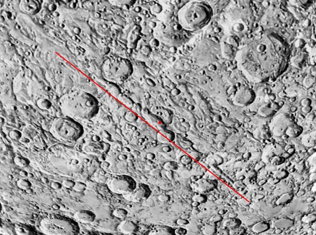 |
My first attempt to resolve this question was to use the Whole Moon option in the VMA which enables one to rotate the Moon round its polar axis. The view of Vallis Rheita from this perspective is shown here and the valley looks almost straight. (The red line is simply a straight line drawn slightly offset from the valley to emphasise its apparent linearity.) However we are still not seeing the valley as it would appear from directly overhead, but from a long way above a point on the Moon at 51°E, 2° 41' N. Perspective is still playing a part.
|
|
|
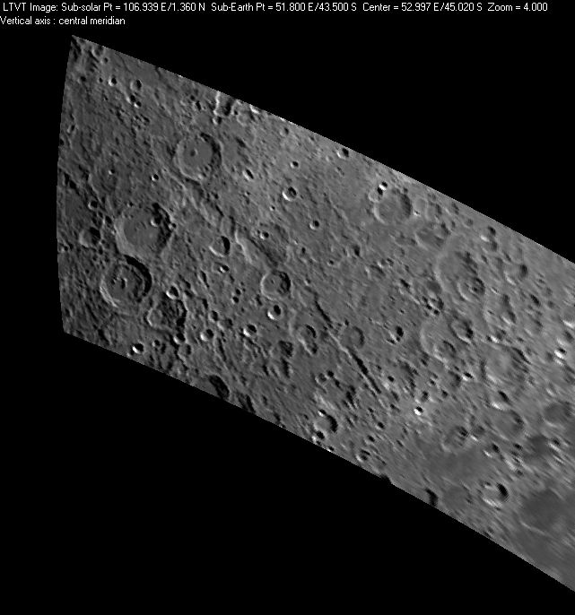
There are now several pieces of software that enable one to look at any part of the Moon from any direction we please. This is my picture above but redrawn by the
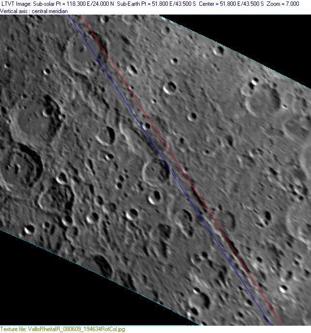
Lunar Terminator Visualisation Tool (LTVT) to show how it would look from a point directly above Young D. It can be seen that the valley is much more nearly linear than it appears in the view from Earth, but far less so than appears in the image derived from the VMA. By drawing lines along the two parts of the valley, I estimate that the deviation is about 12°, compared to more like 25° in the picture at the top.
My last question is "Is either part of the Rheita Valley truly radial to Nectaris?".
This is a significant question related to the origin of these valleys. They are clearly chains of craters and the most likely source is ejecta from the formation of a large crater or a basin. Nectaris is the closest such basin. It turns out that is not such a straightforward question to answer.
|
|
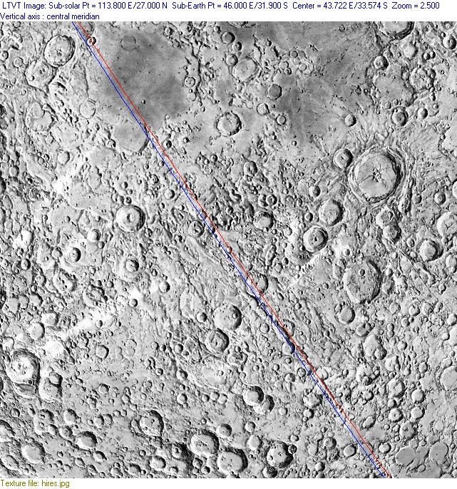
Charles Wood in his book The Modern Moon states (page 105) "In fact, Hartmann showed that the narrower Mallet Valley, as he called it, is exactly radial to the center of Nectaris, and the Rheita Valley is only tangential to the basin's inner ring.". Hartmann showed this by projecting a photograph of the Moon onto a sphere and then rephotographing it from directly over the valleys. Today we have powerful computer programs like the LTVT to do it for us. I'm not sure of the best way to show that a linear feature on the surface of a sphere lines up with a distant object. However it seemed to me that drawing a great circle through the valley would be the best way to do this. I have used the LTVT to draw these circles by moving the Sun in such a way, relative to the Moon, that the terminator runs along the valley. It seems to me that the terminator must be a great circle. (The LTVT draws two lines for the terminator because the Sun is not a point source, but I have used the red line for my purpose, so please ignore the blue line.) However, powerful as this tool is, the question is still not easy to answer. The LTVT needs a map of the Moon on which to operate. The simplest way to import such a map in the detail required is to use the maps available in the Virtual Moon Atlas (VMA) and the clearest of these is the aerograph version.
The parameters used to draw these pictures are printed by LTVT above the pictures. I used the images of the Moon from the VMA which are based on pictures from the Clementine spacecraft.
|
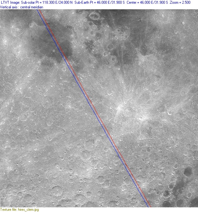
Here I have taken the aerograph version of the Map from the VMA and rotated it to show the view from above Reichenbach Z (which is roughly halfway between the Mallet valley and Mare Nectaris) and adjusted the sub-solar point to be such that the terminator ran along the valley. As you can see here, the line misses the centre of the Nectaris basin quite significantly. I don't believe that such an eminent lunar scientist as W.K. Hartmann was likely to have got it that wrong; far more likely I got it wrong somehow.
At this point I asked the help of Jim Mosher who is the author of LTVT and he suggested that a real photograph of the Moon would be a better representation of the real thing than the aerograph. After all the latter has been extensively retouched, and it is difficult enough to judge the centre of a valley which is really a string of craters, and there is a considerable extrapolation to get to Nectaris. Jim took a beautiful picture of the Moon taken by a group in Minsk in Russia and overlaid a great-circle line (produced rather more neatly than my method) and showed that the Mallet Valley is indeed accurately radial to Nectaris. You can see this picture in the LPOD for 23rd July 2008.
|
|
|
One of the great things about the Moon is that an amateur with a modest telescope can see for himself what it needed professionals to demonstrate only a few years ago. I wanted to try to confirm this alignment with my own photos. Unfortunately I don't have (yet) a picture showing the Rheita and Mallet valleys clearly along with the Mare Nectaris, so I used a rather roundabout route. I put my image of the area into LTVT, aligning it with the Clementine photographic image from the VMA using two large craters that could be distinguished on the high-Sun images. I then rotated the image to see it as it would appear from above, and enlarged it to show the valley as clearly as possible. I then found the sub-solar point that would put the terminator along the valley as nearly as I could judge from my picture (the upper picture here). I then put the Clementine mosaic back into the LTVT and enlarged it rather less so that both the valleys and the Nectaris basin were visible. Using the same subsolar point as I had determined on my picture, I drew the great circle which passed along the Mallet Valley and this picture is shown below. It can be seen that the line passes through the centre of the Nectaris basin to well within the error limits of my method. The mouseover of either image shows the alignment of the Rheita valley done the same way.
So I have confirmed to my satisfaction and from my own photograph that the Mallet valley is indeed radial to the centre of the Nectaris basin, and that the Rheita valley is tangential to the inner ring of that basin. I'm pleased! And my thanks to Jim Mosher and his LTVT software, the VMA, and the operators of the Clementine spacecraft for their assistance.
|
Home Back to SE Quadrant