
Move your mouse over the picture to see the names of the various craters.
 Separating the two great maria, Imbrium and Serenitatis, are two mountain ranges, the
Apennine and the Causasus. The former are arcuate to the Imbrium basin and were undoubtedly
formed by the impact that formed that basin. However, the Caucasus Mountains are
arcuate to neither Imbrium nor Serenitatis, so how did they form? The clue may lie in
the fact that the Serenitatis basin is somewhat younger than the Imbrium basin. Maybe
what happened was that the Serentatis impact raised the Caucasus mountains in an arc running
from the current position north of Serentatis round to somewhere in the region of the current
Autolychus. A few million years later the Imbrium impact occurred and the upheaval,
which should have produced a arc of mountains where the Alps now are and linking up
with the Apennines, effectively pushed the Caucasus mountains to their present position.
The other mountains ringing the Serentatis basin are the Haemus in the south, and
the Taurus in the East. The Taurus mountains are not visible in this picture because
the Sun had set on them.
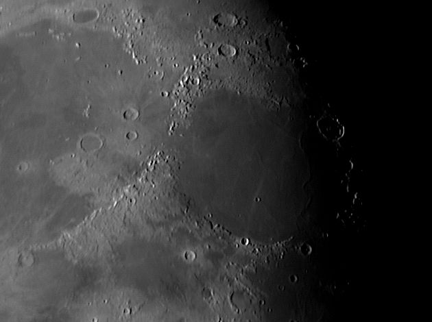
Separating the two great maria, Imbrium and Serenitatis, are two mountain ranges, the
Apennine and the Causasus. The former are arcuate to the Imbrium basin and were undoubtedly
formed by the impact that formed that basin. However, the Caucasus Mountains are
arcuate to neither Imbrium nor Serenitatis, so how did they form? The clue may lie in
the fact that the Serenitatis basin is somewhat younger than the Imbrium basin. Maybe
what happened was that the Serentatis impact raised the Caucasus mountains in an arc running
from the current position north of Serentatis round to somewhere in the region of the current
Autolychus. A few million years later the Imbrium impact occurred and the upheaval,
which should have produced a arc of mountains where the Alps now are and linking up
with the Apennines, effectively pushed the Caucasus mountains to their present position.
The other mountains ringing the Serentatis basin are the Haemus in the south, and
the Taurus in the East. The Taurus mountains are not visible in this picture because
the Sun had set on them.
The scale markers are approximately 200 Km north and east. In pictures taking in a
large expanse of the Moon, such as this, the scale and direction of north varies somewhat
in different parts of the picture. These markers apply around Autolycus and the northern
part of the Apennine mountains.
The picture was taken with a ToUcam attached to my LX200 on 23rd September 2005 at 03:20 UT,
when the Moon was 20.1 days old.
Date and Time
23rd September 2005 03:20 UT
Camera
ToUcam 740K
Telescope
LX200 with 0.33 focal reducer and IR-pass filter
Capture
K3CCDTools. Low gamma, 1/33", 20% gain, 313 frames
Processing
Registax. 85 frames stacked. Wavelet 1 = 10, gamma 1.3
Home Back to NE Quadrant