Move your mouse over the picture to see the names of the various features.
Here we see three pictures of Copernicus at gradually increasing magnifications. The pictures were all taken an 12th November 2005 when the Moon was 11.4 days old.
|
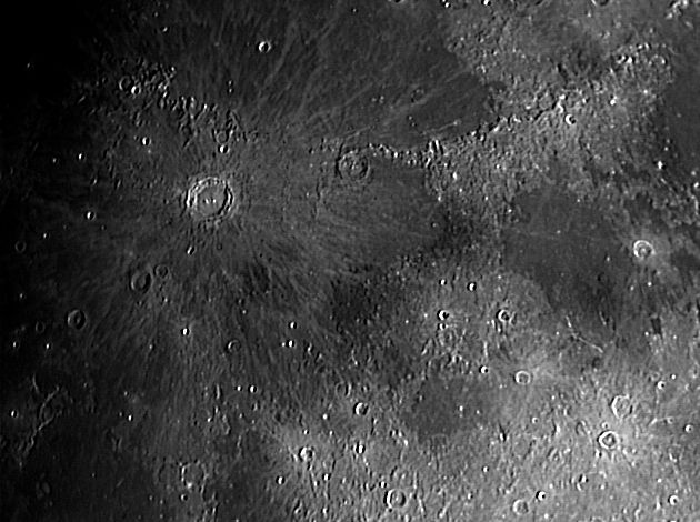
This picture was taken with a 0.33 focal reducer on my LX200, and shows Copernicus in its setting just outside the southern rim of Mare Imbrium, marked by the Apennine and Carpatus mountains. Clearly visible here are the rays of bright material radiating out from the crater. These are caused by secondary pits produced by debris thrown out of Copernicus by the impacting missile, and bits and pieces of bright rocks excavated from below the lava by the impact. The scale markers are approximately 250 Km north and west. Date and Time: 12th November 2005 20:35 UT Camera: ToUcam 740K Telescope: LX200 with 0.33 focal reducing lens Capture: K3CCDTools. 0% gamma, 1/250", 30% gain, 513 frames Processing: Registax. 168 frames stacked. Wavelets 1 = 10, 2 = 5, histogram 0-150 |
|
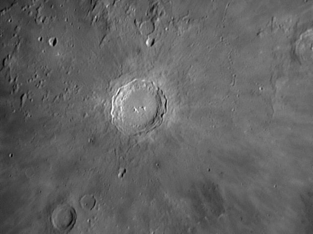
This picture was taken at prime focus of the LX200. The view is now close enough in that Copernicus dominates the picture and we can begin to see the detail within the crater itself. The scale markers are approximately 100 Km north and west. Date and Time: 12th November 2005 17:58 UT Camera: ToUcam 740K Telescope: LX200 at prime focus with IR-pass filter Capture: K3CCDTools. 0% gamma, 1/33", 25% gain, 404 frames Processing: Registax. 41 frames stacked. Wavelet 1-2 = 10, histogram 0-200 |
|
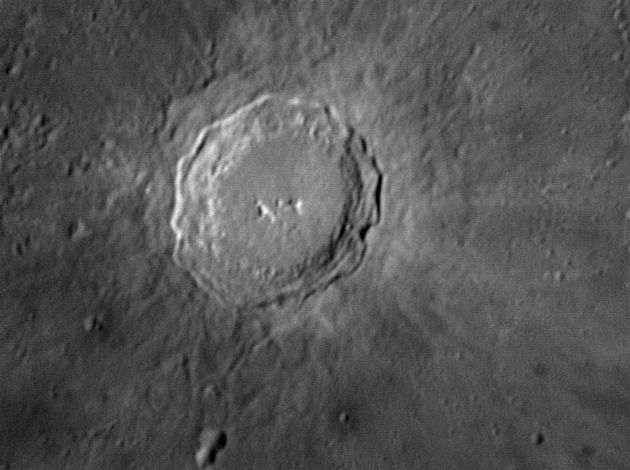
And now with a X2 magnifying lens attached, we see the full details of the crater Copernicus and almost nothing else. What we can see here are some typical features of larger impact craters. The enormous energy of the impactor pushes the rocks aside and they behave more like a fluid than a solid. These craters are not as deep as they would be expected to be by extrapolation from smaller craters and this seems to be because, immediately after the impact, the fluidised rock flows back in towards the centre of the pit. Molten rock is also produced which partially fills the hole. The net effect of all this is that the central mountain is not as high (1,200 metres) as would be expected (~2,500 metres) and the walls slump into a series of terraces separated by steep scarps. These terraces can be seen quite clearly in my picture. Another feature, which is not so clearly seen (but see mouseover) is that the crater seems to stand on a platform, known as a glasis. The platform results in part from an uplift of rocks caused by the initial impact, and partly from the ejected material falling back onto the surface. (This can be seen more clearly in the first two pictures on my general Copernicus page.)
The scale markers are approximately 50 Km north and west. Date and Time: 12th November 2005 18:26 UT Camera: ToUcam 740K Telescope: LX200 with IR-pass filter Capture: K3CCDTools. 0% gamma, 1/25", 52% gain, 404 frames Processing: Registax. 417 frames stacked. Wavelet 1-2 = 10, 3 = 5, histogram 20-140 |
I have an even bigger picture taken at a very similar phase but 16 years later here. The optics are the same as for the picture above, but a more modern camera was used and the image enlarged by another factor of two by the drizzle technique in Registax. The picture opens in a new window, and is rotated about 25° clockwise relative to North at the top.
Home Back to NW Quadrant Page 1